
Publications
Reorientation in Virtual Environments using Interactive Portals
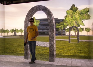
Real walking is the most natural method of navigation in virtual environments. However, physical space limitations often prevent or complicate its continuous use. Thus, many real walking interfaces, among them redirected walking techniques, depend on a reorientation technique that redirects the user away from physical boundaries when they are reached. However, existing reorientation techniques typically actively interrupt the user, or depend on the application of rotation gain that can lead to simulator sickness. In our approach, the user is reoriented using portals. While one portal is placed automatically to guide the user to a safe position, she controls the target selection and physically walks through the portal herself to perform the reorientation. In a formal user study we show that the method does not cause additional simulator sickness, and participants walk more than with point-and-fly navigation or teleportation, at the expense of longer completion times.
Best Technote!
@INPROCEEDINGS{freitag2014,
author={S. Freitag and D. Rausch and T. Kuhlen},
booktitle={2014 IEEE Symposium on 3D User Interfaces (3DUI)},
title={{Reorientation in Virtual Environments Using Interactive Portals}},
year={2014},
pages={119-122},
doi={10.1109/3DUI.2014.6798852},
month={March},
}
Poster: Visualizing Geothermal Simulation Data with Uncertainty
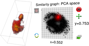
Simulations of geothermal reservoirs inherently contain uncertainty due to the fact that the underlying physical models are created from sparse data. Moreover, this uncertainty often cannot be completely expressed by simple key measures (e.g., mean and standard deviation), as the distribution of possible values is often not unimodal. Nevertheless, existing visualizations of these simulation data often completely neglect displaying the uncertainty, or are limited to a mean/variance representation. We present an approach to visualize geothermal simulation data that deals with both cases: scalar uncertainties as well as general ensembles of data sets. Users can interactively define two-dimensional transfer functions to visualize data and uncertainty values directly, or browse a 2D scatter plot representation to explore different possibilities in an ensemble.
Interactive Definition of Discrete Color Maps for Volume Rendered Data in Immersive Virtual Environments
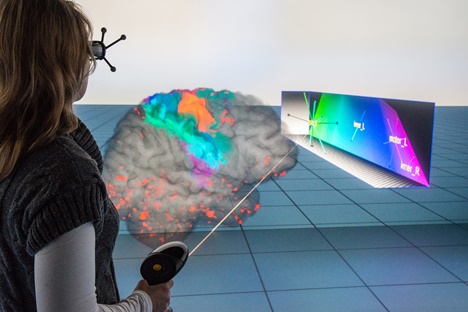
The visual discrimination of different structures in one or multiple combined volume data sets is generally done with individual transfer functions that can usually be adapted interactively. Immersive virtual environments support the depth perception and thus the spatial orientation in these volume visualizations. However, complex 2D menus for elaborate transfer function design cannot be easily integrated. We therefore present an approach for changing the color mapping during volume exploration with direct volume interaction and an additional 3D widget. In this way we incorporate the modification of a color mapping for a large number of discretely labeled brain areas in an intuitive way into the virtual environment. We use our approach for the analysis of a patient’s data with a brain tissue degenerating disease to allow for an interactive analysis of affected regions.
@inproceedings{Hanel2014a,
address = {Minneapolis},
author = {H{\"{a}}nel, Claudia and Freitag, Sebastian and Hentschel, Bernd and Kuhlen, Torsten},
booktitle = {2nd International Workshop on Immersive Volumetric Interaction (WIVI 2014) at IEEE Virtual Reality 2014},
editor = {Banic, Amy and O'Leary, Patrick and Laha, Bireswar},
title = {{Interactive Definition of Discrete Color Maps for Volume Rendered Data in Immersive Virtual Environments}},
year = {2014}
}
On The Impact of Spatial Heterogeneous Permeability Distributions on the Development of Free Convection Cells in the Perth Basin, Australia
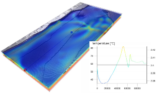
When dealing with free convection in a geothermal reservoir, it is preferable to detect regions of up flow, which locally increase the geothermal gradient. Free convection cells are likely to be found in a large reservoir layer (Yarragadee Aquifer), which is encountered in the entire Perth Basin, including the Perth Metropolitan Area (PMA). While the knowledge about the structure of the Perth Basin has been improved recently, the heterogeneity and spatial complexity of permeability was up till now mainly neglected. We set up a refined structural model of about 5000 km² comprising the region around the city of Perth up to a depth of 4.5 km, using an implicit modelling approach (3D GeoModeller by Intrepid Geophysics ). Based on the structural model we create a discretized numerical model for simulating fluid flow and heat transport in the Yarragadee Aquifer considering spatial heterogeneity of porosity and permeability. This heterogeneity is assessed by designing three different test cases: 1) constant porosity and permeability for the entire aquifer; 2) porosity and permeability decreasing with depth; 3) a conditional random permeability field within prescribed limits and for given correlation length. We calibrate a poro-perm relationship based on a fractal approach to the Yarragadee Aquifer, using over 100 measurement pairs of porosity and permeability from three boreholes. This data was also used for calibrating porosity decrease with depth, following Athy’s law. For the model with constant porosity and permeability, convection cells vary in size between 4 km and 6 km. Simulations with depth dependent decrease in porosity and permeability yielded a transition from conductive to convective heat transport in the Yarragadee Aquifer at a threshold permeability of around 1.7 × 10⁻¹⁵ m². There convection cells are much smaller, at the scale of 2.4 km to 3 km. Stochastic distributions of porosity and permeability in the Yarragadee cause the formation of convection cells to adjust to the permeability field, yielding a less distinct convection pattern. Where the Yarragadee Aquifer is in contact with overlying aquifers, stable regions of down flow develop. These in turn have a strong impact on the regional flow field and therefore on the temperature distribution. Temperatures drop to about 40 °C in 2 km depth. In order to improve the reliability of the model, as well as identification and comparison of convection cells in different simulations, we are developing a specialized visualization tool tailored to this purpose. By using tools like particle tracing and direct volume rendering, the recognition of the spatial distribution of convection cells and their change in the different cases facilitated.
Previous Year (2013)
